Editor’s Note: This is a continuation of our Policy Summit series of articles by the panelists, speakers, and Great Upheaval contestants. The below is an article by Greg Rogers and Patrick Smith of The Autonomer. View their full website here.
On congested urban streets, America’s burgeoning ranks of rideshare drivers face constant challenges in picking up and dropping off passengers. Consistently unable to find a legal space in which to wait, they frequently have to turn on their hazards and block entire traffic or bike lanes—or gamble on pulling aside to a nearby bus top, commercial loading zone, or fire hydrant, where they risk a hefty moving violation. Meanwhile, cyclists are left to swerve dangerously around the car and approaching passengers caught in the confusion.
Uber alone has over 400,000 registered drivers; most are in urban areas, and most experience this same risk exposure every time they drive. Quite simply, rideshare, an exploding segment of transportation that holds great promise for urban sustainability and mobility, does not yet have a home on our streets.
Shared-Use Mobility (SUM) Zones were conceived in order to change that. By using robust data analytics and congestion analysis, cities can identify a select number of urban parking spaces to repurpose into shared transportation zones for the safe pick-up and drop-off of passengers, mitigating congestion and improving accessibility, safety and efficiency for all users.
The example below shows a street in Gramercy Park, in Manhattan. Streets like this across New York City, DC, and countless other cities give rideshare drivers nightmares.
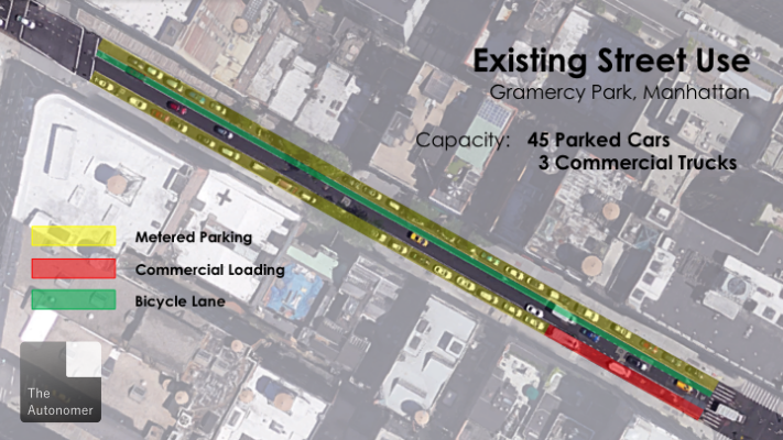
A single lane of traffic, a bike lane, and two completely full parking lanes: one rideshare pickup can completely shut this street down. But when just a few of the 46 parking spaces are converted to SUM Zones, that worry goes away.
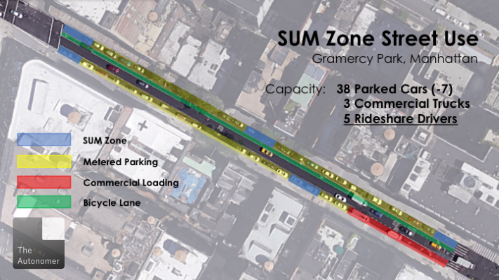
The vision is to create a network of spaces on each block that ensure that wherever vehicles arrive to wait a couple minutes for their passengers, they can do so safely, without shutting down the free movement of traffic on which our transportation systems depend.
Through integration with ride-sourcing platforms, each time a ride is requested, both drivers and passengers will be shown the location of the nearest SUM Zone. The passenger will be picked up and dropped off at the legal SUM Zone, loading zone, or parking space closest to their destination. For uses that don’t (yet) involve the internet, the widespread proliferation of SUM Zones, complete with a particular asphalt painting scheme and signage where appropriate, will make sure they’re easy to locate when they’re needed.
SUM Zones make transportation more accessible and safer for a broad range of users, but the benefits will be particularly pronounced for the elderly and people with disabilities. Typically underserved by traditional mass transit systems, they rely on either paratransit services, like New York’s Access-A-Ride vans, taxis or, increasingly, rideshare services. However, when parked cars line residential streets and force the vans to double park, their customers struggle to access the vehicle, particularly when it limits ramp deployment. In designating SUM Zones, at which pick-up vehicles can directly access the curb, cities can improve the ease of mobility of this vulnerable group, and ensure that the services that provide them don’t obstruct other road users in the process.
More broadly, true rideshare services, like Split, Via, Google’s RideWith, UberPool and Lyft Line are in development or actively rolling out. Smartphone-enabled carpooling apps, such as GoKid, aim to enable much greater efficiencies in car usage. These services will continue to gain popularity, and ensure that ever-larger numbers of drivers will need safe places at the curb to wait for up to a few minutes while their passengers emerge.
Though re-designating parking spaces as SUM Zones will provoke some opposition, as does the repurposing of any urban parking spaces, there are several precedents. San Francisco is testing a two-year pilot of roughly 150 parking spaces specifically for carshare services, like City Carshare and Zipcar, and analogous spaces can be seen around Washington, DC. Similarly, Bikeshare programs, such as CitiBike in New York City, often take over one or multiple on-street parking spaces to site a station. Like SUM Zones, these involve repurposing parking spaces in support of conscious efforts by municipalities across the country to encourage a shift in our transportation paradigm toward more convenient, environmentally friendly, and cost-effective options. And there are immediate benefits to be reaped by communities and businesses that embrace SUM Zones. By letting go of a couple parking spaces, they make it much more likely that when they need to use the street, traffic will be moving freely.
Further, it will be important to demonstrate the spots were carefully selected, and show these potential benefits through modeling. Leveraging publicly-accessible data and partnerships with transportation network companies (TNCs), carpooling platforms, and paratransit services, supplemented by real-time observation, municipalities or third parties can use the existing wealth of logistical information to determine where these spaces are needed most, and make those results available to the community. This analysis will consider numbers of pick-ups and drop-offs, existing parking availability and utilization, and recurring congestion levels, along with any other factors the city identifies. The program is versatile by nature—it can be deployed exclusively in congested central business districts, or widely, to include mixed and primarily residential districts. In places where only peak commute hours necessitate passenger access zones, SUM Zones could transition to commercial loading zones—addressing a major challenge relating to package truck double parking—or revert to metered parking during off-peak hours.
Technological solutions in vehicle-to-infrastructure and vehicle-to-vehicle communication will only increase the efficiency of SUM Zones. Sensors could be used to monitor the spaces and direct rideshare drivers to the nearest unoccupied space, preventing overflow congestion when SUM Zones fill up. Linking them to universal Wi-Fi initiatives would also expand their function, allowing travelers without cellular data connections, like most tourists, to explore another transportation option. Finally, as autonomous vehicles technology matures, SUM zones will provide critical sensor-identified locations to which vehicles can route, allowing for smooth, safe pick-ups and drop-offs without disrupting traffic.
There is certainly enormous potential for customization and growth, based on each city’s needs and initiative. Across our nation’s urban centers, there is a shared need for a new look at how curb regulations prioritize transportation choices, and the benefits communities stand to reap from reorienting. SUM Zones are just such a reorientation. Under a wide implementation and education program, they will be a critical part of the transition to a new phase of urban transportation—one that is safer, faster, and more reliable for everyone.
