No one can deny that drones (officially known as Unmanned Aerial Vehicles or UAVs) are one of the hottest Christmas list items out there right now – probably hovering right above Just Charms on everyone’s Amazon wish list. However these miniature flying devices, while they have major benefits, also have the potential to wreak havoc on our airspace system. Incidents of this type have prompted the Federal Aviation Administration (FAA) to require all drone operators to begin registering their drones as of December 21.
Registering drones will not solve all drone related policy challenges such as close calls with airplanes, security risks, and insurance concerns. But, soon enough there will be hundreds of UAVs competing for airspace. So how do you keep drones, planes, helicopters, and the unsuspecting public below safe from these potential risks? By creating an air traffic control (ATC) system for UAVs that assists in preventing collisions and crashes.
How would such a system work?
A traditional air traffic control system is one that is monitored continuously by personnel and uses a system of either radar or satellite-based technology. A UAV air traffic control system would differ in a number of ways.
The vision is a low-altitude system – likely below 500 feet since anything above that is classified by the FAA. (See this very useful diagram.) A controlled system could keep drones from running into each other, buildings (especially airports), planes, helicopters, people, UFOs, etc. It would not require constant human operation, and, according to the National Aeronautics and Space Administration (NASA), it could perhaps leverage “concepts from the system of roads, lanes, stop signs, rules and lights that govern vehicles on the ground today”
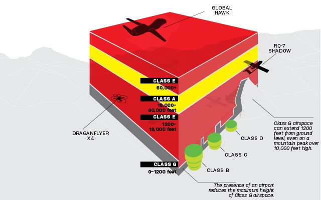
FAA Airspace Classification Guide (via Popular Mechanics)
Why is a separate air traffic control system necessary?
According to this article the reasoning behind a separate system is based on numbers. The FAA employs approximately 15,000 controllers who manage around 87,000 flights per day. Predictions for drone usage dwarf those numbers. Hao Yi Ong, UAV traffic management researcher with the Stanford University Mechanical Engineering Department adds, “You’re not going to hire another 30,000 people just to handle traffic from drones. It’s just not feasible.”
Why NASA? Why doesn’t the FAA take the lead on this?
Managing a system like this is a huge undertaking; the general consensus among key stakeholders is that they do not want the FAA to attempt to manage it. However, the FAA is not completely out of the picture. Bob Poole, Director of Transportation Policy at the Reason Foundation adds, “[The FAA] nominally control[s] all airspace. They will have to give it their blessing.”
Instead, NASA has come forward as the broker for this plan; citing their “legacy of work in air traffic management for crewed aircraft” as a reason for taking the lead on research and development. As such, they have proposed a UAV traffic management system (UTM).
The UTM system is still in its preliminary stages, but NASA has stated that it is exploring prototype technologies for a UTM. It has two types of systems in mind: A Portable UTM system and a Persistent UTM system. A portable system would move between geographical areas and a persistent system would provide consistent coverage of one geographical area.
According to the NASA UTM homepage, “…the UTM system would enable safe and efficient low-altitude airspace operations by providing services such as airspace design, corridors, dynamic geofencing*, severe weather and wind avoidance, congestion management, terrain avoidance, route planning and re-routing, separation management, sequencing and spacing, and contingency management.”
*Geofencing is defined as, “…a feature in a software program that uses the global positioning system (GPS) or radio frequency identification (RFID) to define geographical boundaries. A geofence is a virtual barrier. “ (Incidentally, you can get your very own geofence if you’re not interested in drones buzzing around your house – Here’s how to set up a no-fly drone zone over your house)
Joseph Rios, NASA UTM Project Lead added, “Many of the tools and systems that we’ve developed have transitioned into the national airspace system. We’d like to leverage some of that to help bring in stakeholders and use our unique position as a research agency to come up with an effective, safe solution to the UTM problem that we can then advocate to the FAA as a potential way to implement the system.”
NASA has completed one round of field testing and has plans for at least three more rounds of tests. This first round was held in August 2015 and examined “operations for agriculture, firefighting, and infrastructure monitoring, with a focus on geofencing, altitude ‘rules of the road’, and scheduling of vehicle trajectories”
Google has also thrown their hat in the ring in pursuit of creating a fleet of UAVs that would provide emergency medical services – or, medical drones. (They recently received a patent allowing the manufacture of these flying ambulances)
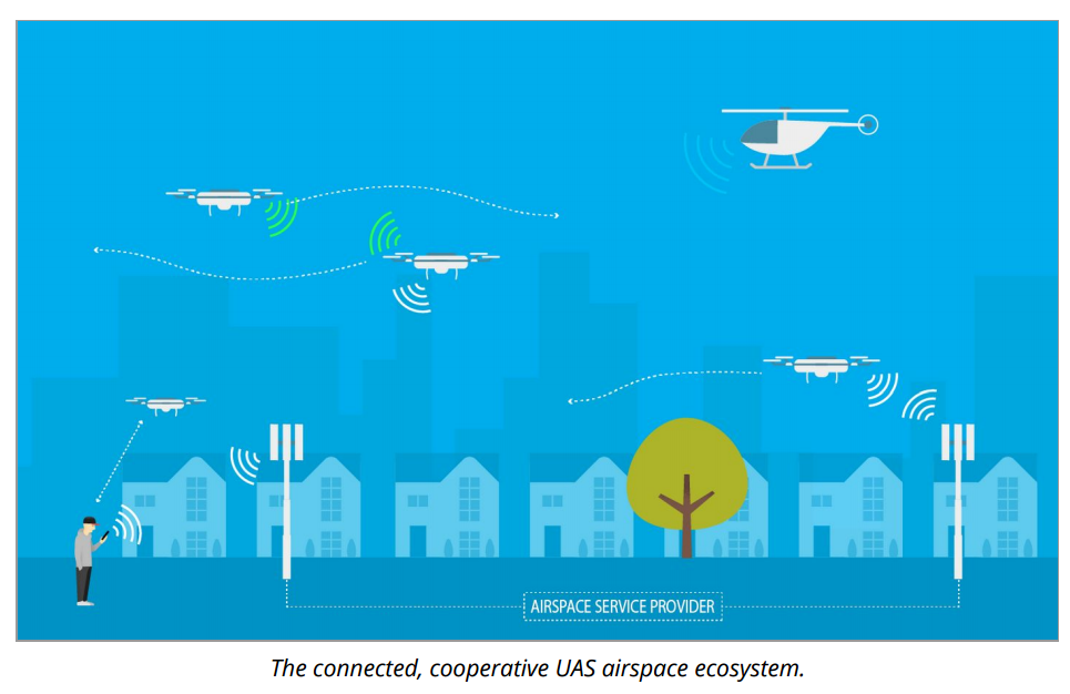
Their plan for implementation? Airspace Service Providers (ASPs). This would be a lightweight, low-cost ADS-B device on every aerial vehicle flying in a low-altitude airspace. This system would rely on existing infrastructure (likely cell towers), monitor flights under 500 feet, and also include vehicle-to-vehicle communication. It would also act as an interface between UAV operators and the traditional ATC system and provide UAV operators with a database of No-Fly-Zones, weather notifications, flight plans, etc.
Google’s system is only in its preliminary stages and many questions have been left unanswered. When asked at the Air Traffic Control Association (ATCA) Convention in November, David Vos, head of Google’s Project Wing was not extraordinarily specific about security, drone identification, or funding. Google has, however, provided a system overview that includes a section on “Identification and Security”.
Amazon has made headlines as well over the past two years as they begin lobbying for drone delivery service that would enable customers to have goods shipped within 30 minutes of your order. This sneak peak at their new drone prototype hints at a more sophisticated system of safety and avoidance for these UAVs but doesn’t provide much detail.
In this paper, Amazon lays out their plan for safe UAV operation. Amazon states, “[we] believes the safest and most efficient environment for sUAS (small unmanned aircraft systems) operations… is in segregated civil airspace below 500 feet.”
The visual below provides a good look at what Amazon is proposing.

Amazon also proposes that there be one central controlling agency that serves as the coordinator by enforcing established rules – think NASA’s UTM and altitude “rules of the road” mentioned earlier – and who would interface with the FAA so that the new UTM would be in line with existing FAA ATC regulations. They give NASA an endorsement and state that they will cooperate with stakeholders “large and small” to develop a system for safe UAV operation.
Verizon is working with NASA as well and reportedly signed an agreement with NASA to explore the use of cell towers as communications and surveillance for UAVs.
According to Bob Poole, RTCA, Inc. is expected to join the UAV research and development effort in the coming year as part of the overall effort to interface this UTM system with the FAA. RTCA is already involved with NASA on Special Committee 228, which has been working to develop performance standards for large UAVs since 2013. This new initiative will focus on UAVs weighing less than 55 pounds and would develop performance standards for commercial UAV use (not recreational).
Expected growth in the drone industry over the next several years is sky high and the companies getting into the drone game include non-traditional stakeholders (Even Facebook wants in on UAVs). The emerging drone industry has also spawned the world’s first “Droneport” – an airport for drones.
One thing is certain; starting on December 25 that is likely not a bird or a plane – it’s probably a drone.

