Guest Op-Ed: Annoyance and Drones: How Optimizing Flight Paths Can Reduce Potential Noise Impacts
Drones are cost effective and easy to operate. However, the same physical characteristics that make multicopter drones appealing, such as their small size and associated high/irregular blade speeds, also contribute to their distinctive buzzing sound—which, as it turns out, is often annoying.
Their annoyance is confirmed in research conducted by the National Aeronautics and Space Administration. It found listeners consistently rank multicopter drone noise as more annoying than noise from delivery trucks or cars due to psychoacoustical properties not easily modeled by traditional acoustical metrics.
Since 2017, the Federal Aviation Administration (FAA) has operated the UAS Integration Pilot Program (IPP) to accelerate safe drone operations. Despite this framework, no guidance exists at the federal level to inform drone design or routing with noise annoyance in mind. Without a clear regulatory framework, acoustical optimization of drone flight paths offers the greatest promise for commercial drone operators looking to chart a path ahead in the short term without jeopardizing the momentum of the moment.
Adopting a proactive approach is important for two reasons.
First, multicopter drone noise is expected to increase over the next decade as more companies receive waivers from the FAA to operate drone delivery programs. Companies like Wing (Alphabet), UPS, and Amazon have received approval to operate their services. Walmart is also working with two separate companies to deliver goods by drone in Arkansas and North Carolina. Moreover, the pandemic-induced demand for contactless delivery has also accelerated their use and reach.
Second, operating continuous drone delivery routes over populated areas without modeling the acoustical impacts risks inciting a backlash. In 2018, Wing began operating a drone delivery service in Bonython, a township in southern Canberra, Australia. While initially welcomed, residents soon revolted, comparing the noise to sounds of war and dental drills. Australia’s federal government investigated and concluded the noise fell within its regulatory purview.
Using noise maps to plan for and mitigate drone-associated noise could lessen the likelihood residents will object to continued overhead drone operations. Noise maps show operators how the sound of one or more sources propagates through a community. They are appealing in the context of drones because they allow users to apply a consistent method to estimate noise exposure over a large population. Noise maps also function as a tool to analyze routing options to reduce potential impacts.
Noise mapping is common in the United States at a project-level scale for specific sources of sound such as airports, manufacturing and commercial facilities, energy production facilities, and highway sections. The National Park Service (NPS) has also collected sound levels from its parks across the United States. At a larger scale, regional noise maps are seen in Europe due to its Environmental Noise Directive (EU Directive 2002/49/EC), which requires such maps in areas with high population densities. However, few regional noise maps exist in the United States since no law or regulation requires their production.
Because commercial drone operations could comprise hundreds of daily flights over an area, modeling delivery drone routing to optimize community noise mitigation near flight paths is important. This mitigation can be accomplished using regional and local noise mapping to identify areas where existing background noise may mask drone sounds.
Since negative reaction to drone noise is a function of annoyance, and audibility precedes annoyance, identifying opportunities for masking can reduce the impact of drone operations. To facilitate this, noise mapping may need to expand beyond the prediction of overall sound level, which is how it has typically been applied. The acoustical profile of drones is unique, with many distinguishable tones, which may require noise mapping of specific audible frequencies to identify opportunities for masking.
Geographic information system data and noise mapping can help identify low-impact areas for routing. Low-impact areas from a noise perspective could include drone routing over railways, roadways, or bodies of water since these paths already facilitate transportation and produce some volume of noise through commercial operations. Waterways and working landscapes may also provide opportunities for routing over uninhabited areas.
As an example, our team modeled a hypothetical situation to show how noise mapping can be used to identify drone routing options to minimize noise exposure to populated areas. The figure below shows the sound levels in isoline format from a hypothetical hour of drone deliveries to 50 locations in Chittenden County, Vermont, using Lake Champlain as the primary route. It shows spurs to each delivery location. The sound level isolines from drones are overlaid on an existing noise map that shows the ambient daytime sound levels in Chittenden County from roadway and railway noise.
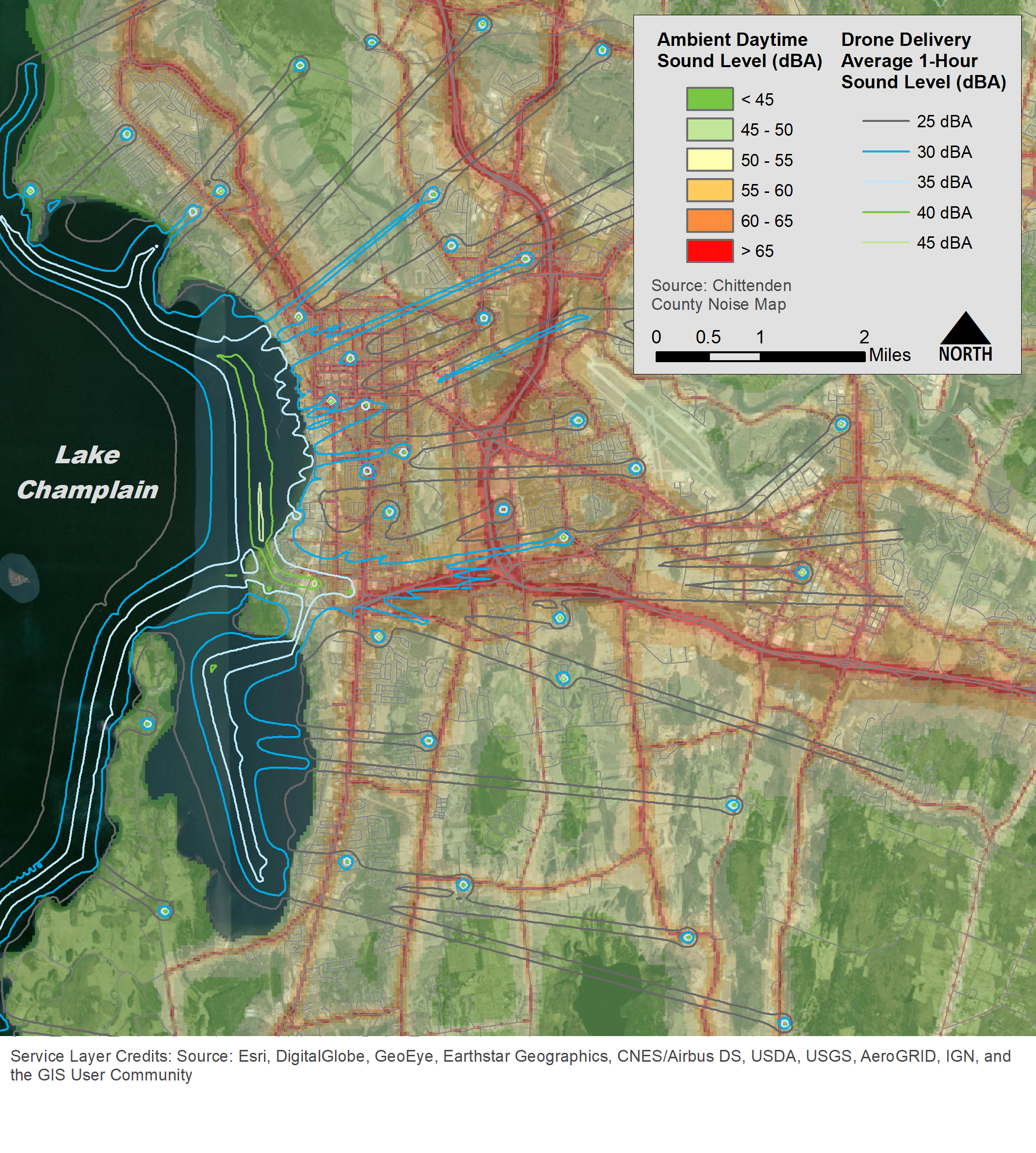
Sound emissions for the modeled drone were provided by W. Nathan Alexander, an assistant professor at Virginia Polytechnic Institute and State University (Virginia Tech). More details about the measurement methodology can be found in Virginia Tech’s 2019 Inter-Noise paper.
Our research found the drone sound is greater over the lake where the main route corridor is modeled. Lower sound level spurs extend out over the land to the final delivery destinations. While this map shows a hypothetical average one-hour overall sound level, additional analyses can be done to show maximum sound levels of passbys over specific areas.
Eventually, these noise maps can enable customized routing that focuses on hybrid routes over various landscapes and land uses. Such routes can minimize potential noise impacts to the population within earshot of a drone delivery region.
To that end, the current FAA IPP permitting framework could be expanded to encompass additional reporting and routing requirements for operators. For instance, operators could be required to report drone sound emissions by device type (since these vary considerably). Operators could also be required to demonstrate consideration of equity/environmental justice since minority neighborhoods have been shown to bear a disproportionate burden when it comes to existing environmental noise pollution.
Finally, because drone noise annoyance is not easily quantified, requiring drone operators to fall below a certain sound level threshold established by the federal government would not alone address the concern. Instead, operators should be required to demonstrate how their routing is tailored to reduce/mask the sound of their drones using noise mapping of a region. Over time, the consistent collection of such data at the federal or state level will also help with future noise mapping activities.
The views expressed above are those of the author and do not necessarily reflect the views of the Eno Center for Transportation.

