Community-Supported Plan Fuels Transportation Transformations
Sometimes neighborhood plans sit on the shelf—but sometimes they contain the right ingredients, bring together the right partners, and show community support for funding and implementation of transportation projects.
This story is centered in Chicago’s vibrant Lincoln Square neighborhood on the city’s Far North Side. In 2018, the local chamber of commerce hired our firm, Teska Associates (a community planning and landscape architecture firm located in nearby Evanston), to lead a neighborhood master planning process. With community engagement as the central pillar, the master plan was adopted in 2019 and addresses transportation and urban design priorities, shaped by input from thousands of residents via stakeholder interviews, pop-up events, online polls, and community meetings. The document serves as a guide that the Special Service Area (SSA) #21 and Lincoln Square Ravenswood Chamber of Commerce will look to over the next five to 10 years to make strategic decisions on where to spend funds and how to make improvements, both big and small.
One area of plan recommendations focused on extending the success of Lincoln Square’s vibrant, walkable, and transit-oriented business district to the surrounding corridors, which are more auto-oriented. Residents also expressed a desire for more people-places — venues catering to pedestrians rather than cars — and areas to gather.
From the master plan, three projects have emerged that are transformative to how residents and visitors traverse and experience this neighborhood.
Project #1: Ainslie Arts Placemaking, From Parking to People-Place
An opportunity to reimagine a formerly auto-centric block, typically used as parking for a McDonald’s, came at the right time as the community began its implementation efforts. With a willing private property owner — the McDonald’s renovation plans set the process in motion — and local leaders committed to implementing their neighborhood plan, collaboration and partnerships began to blossom.
In partnership with the local SSA, Alderman’s Office (40th Ward), Chicago’s Department of Planning and Development, the city Department of Transportation (CDOT), the property owner, residents, and local artists, the future Ainslie Arts Plaza began to take shape via CDOT’s Make Way For People Program.
Engagement resulting from the Lincoln Square Master Plan process showed that residents wanted more pedestrian amenities, public art, landscaping, and public gathering places. With an opportunity to bring all of these elements together, more focused community polling and a town hall revealed specific desires for what a new public place should include. The resulting concept design for the Ainslie Arts Plaza is based on tried-and-true placemaking elements and features that focus on the adaptability of space itself. The design lends itself well to our new way of life during COVID-19, with mobile elements and flexible seating that provide options for safe outdoor gatherings and social distancing. Features of the plaza include:
- A roadway mural produced by a local artist.
- Barrier fencing, art panels, and welcome signage.
- Entry pylons with signs, chalkboards, and engagement activities at the north and south plaza entrances.
- Outdoor seating and dining surrounded by planter cubes, overhead string lights, and picnic tables.
- Flexible areas designed to accommodate makers’ markets, movie nights, yoga and fitness classes, and events.
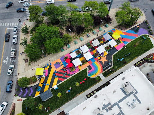
Aerial view of today’s Ainslie Arts Plaza
The success of the small-scale, but mighty Ainslie Arts Plaza has spurred action on two additional Lincoln Square projects with bigger physical footprints. Again, backed by recommendations from the master plan and general community support for such activities, the SSA/Chamber, CDOT, Chicago Transit Authority, and elected officials are partnering and funding projects that will massively improve these transportation assets, increasing multimodal connections and making it easier to walk, bike, and take public transit.
Project #2: North Lincoln Avenue Streetscape
An emerging arts district, North Lincoln Avenue from Lawrence Avenue to Catalpa Avenue has long been recognized as a treeless, auto-dominated corridor with narrow sidewalks and a lack of bicycle infrastructure. Currently in the final design phases and led by CDOT, the Lincoln Avenue Streetscape and Plaza Project aims to increase safety and walkability by adding bike lanes and widening sidewalks, support economic development with outdoor seating and street plantings, and enhance public spaces, including the formalization of the Ainslie Arts Plaza.
Project #3: CTA Western Brown Line “L” Station Area
Just a few blocks south of Ainslie Plaza lies the CTA’s Western Brown Line “L” Station, a well-used (by thousands of daily bus and train riders) but uninviting transit stop in the beating heart of the neighborhood.
The station area includes a series of disjointed spaces, including the transit plaza, a surface parking lot (used for farmers’ markets), a linear walkway under the “L” tracks, and Leland Avenue. Neighbors called for improvements to these areas during the master plan process.
Sponsored by the SSA/Chamber in 2021, the CTA Station Area Study brought the community together through online polling, pop-ups, and community meetings to reimagine these spaces. Following an outpouring of community interest, the 47th Ward Alderman’s Office, CDOT, and CTA have partnered to allocate tax-increment financing to fund portions of this project.
Design features include:
- A new transit plaza with raised planting beds, native trees, integrated and movable seating, string lighting, a vending kiosk, bike racks, and permeable paving.
- An enhanced farmers’ market parking lot with a market shelter, permeable paving, decorative lighting, and native plantings.
- Improvements under the “L” tracks, including sculptural elements, decorative paving, overhead lighting, projected light murals, and native plantings.
- Leland Avenue streetscape improvements, including traffic-calming features and bike lanes.
Final engineering for this project is anticipated to commence by the end of 2022, with construction anticipated soon afterward.
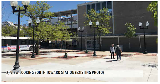
Existing Photo: View looking south toward Western station
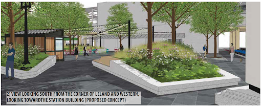
Proposed Concept: View looking south toward Western station
Lessons Learned
- Public rights-of-way are notoriously narrow and placemaking requires space to be effective. Illustrative graphics and models can articulate these issues and opportunities and set the stage for meaningful discussions with communities, agencies, and elected officials.
- Outreach takes time. Listening sessions (without preconceived design ideas) are critical to understand issues, test concepts, and build consensus.
- Stakeholder coordination is key. Roadways and transit stations often have multiple property owners and sometimes competing interests. Early conversations are essential to identify common goals and priorities.
Transit agencies are in the business of infrastructure. But if they can see a construction-ready, community-supported project, they are more likely to sign on.
Francesca Sallinger Lawrence is a Senior Associate Planner at Teska Associates and was an O’Bryant Fellow at Eno Center for Transportation in 2016. Jodi Mariano is Teska’s Principal of Urban Design.

